GPS Satellite Navigation
-
I used to have an amazing collection of maps. They were real important to me. I can remember 20 years ago when I was transferred to Southern Louisiana feeling almost desperate and thinking, “Well at least I have dual gas tanks on this pickup truck and both are full. Surely I will run into a real highway before I run both tanks dry.”
When I accepted the job as General Manager of the European Division of our company I can remember quite well at first I was working 14 hours per day. One night on the way home in the dark I got lost and completely disoriented. I can remember just wanting to pull over and cry. Here I was totally lost in a foreign country where they did not speak English or Spanish. And I was only about a mile from the hotel where I was living.
Well, no more. I now own very few maps. I almost always carry my portable GPS with me, and I have GPSs in both cars and on my motorcycle. The GPS has stored in its non-volatile memory all the streets and roads in America, and it talks to me verbally telling me to turn left or right. It shows a moving map in color.
Over the last few years I have taken pictures of my GPSs in various locations.
To the right is a picture of the GPS I had permanently mounted i n my Toyota Prius in Europe. Since it had a gyroscope built in and was connected to the car’s speedometer and backup lights it could continue to function quite well mile after mile when travelling underground in tunnels. It worked just fine in the Gottard tunnel going through the Swiss Alps and in the long tunnels that go under various parts of Brussels, Belgium and Dusseldorf, Germany. Both cities have turnoffs and exits in their tunnels, so it is important to know where you are even when your GPS cannot pick up the weak satellite signals.
I rode the Thallys high speed train many times. If I got on the first train of the morning just before 8:00 am about 10 miles from my house I could get to Paris, France early. I would spend the whole day in Paris then return on the last train of the evening, and end up getting home at a reasonable time and sleeping in my own bed.
They claimed that this train ran at 300 kilometres per hour (186 mph). One time I turned on my GPS and by holding it right next to the train’s window I was finally able to log onto enough satellites for it to work. I should have expected that the train had an excellent cruise control, and that it ran at EXACTLY 300 km/hr.

Once in England I was near the Roman settlement of Vindolanda when I saw a very small shard of terrasigilata red pottery laying on the ground. So I took a picture of it with my GPS so as to remember the exact location.
In Germany we were in a farmer’s field one day and found some Roman roof tiles. The Roman Legion XV Primigenia was indeed stationed at this location from AD 43 to AD 69.
One of the pieces of roof tile even had the mark of Legion XV imprinted on it. I used my digital camera to take a picture of the GPS so I would be certain to remember the location.
When one travels to the UK it is possible to take one’s own car through the tunnel under the English Channel, but many times I flew over and rented a car there. Since they drive on the other side of the road than is normal in continental Europe and the USA, cars have the steering wheel on the right hand side.
This means that you are driving on the wrong side of the road, in a strange country, the gear shift lever is on the left side of you, you look up and to the left for the rear view mirror, etc. It can be very disorienting, especially if you are alone and you are trying to navigate by a road map.
But with a portable GPS the stress level goes way, way down. This is a picture I took up in the Scottish Highlands in a rent car, to show that the GPS is to the left of the driver.
I drove my Toyota Prius down to Italy.
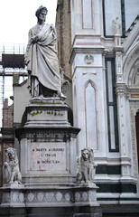
This is a picture of my GPS when I was stopped on the Appian Way in Rome.
One of the nicest trips I ever took to the UK took me to Frazer’s Hush in the North of England. Where I wanted to go was way out in the country and one-lane paved roads.
Since I brought my own GPS with me it was really no problem to navigate that where I wanted to go.
For the last few years I have tended to gravitate to the Garmin brand of GPS. Installing their software is always a headache, but once you get over this hurdle they are excellent machines.
So now that I have moved back to America I have a very large Garmin GPS mounted in the Toyota Corolla. It is not connected to the car in any way (other than 12 vdc from the lighter plug) and does not have a gyro built in. But it works just great anyway.
I guess I have owned 7 or 8 Garmins. Even though the installation process of their software sucks big time, I am completely sold on them. One solution is just to buy a model that already comes loaded with all the roads in America in non-volatile memory. This makes their software almost unimportant.
When I accepted the job as General Manager of the European Division of our company I can remember quite well at first I was working 14 hours per day. One night on the way home in the dark I got lost and completely disoriented. I can remember just wanting to pull over and cry. Here I was totally lost in a foreign country where they did not speak English or Spanish. And I was only about a mile from the hotel where I was living.
Well, no more. I now own very few maps. I almost always carry my portable GPS with me, and I have GPSs in both cars and on my motorcycle. The GPS has stored in its non-volatile memory all the streets and roads in America, and it talks to me verbally telling me to turn left or right. It shows a moving map in color.
Over the last few years I have taken pictures of my GPSs in various locations.
To the right is a picture of the GPS I had permanently mounted i
 n my Toyota Prius in Europe. Since it had a gyroscope built in and was connected to the car’s speedometer and backup lights it could continue to function quite well mile after mile when travelling underground in tunnels. It worked just fine in the Gottard tunnel going through the Swiss Alps and in the long tunnels that go under various parts of Brussels, Belgium and Dusseldorf, Germany. Both cities have turnoffs and exits in their tunnels, so it is important to know where you are even when your GPS cannot pick up the weak satellite signals.
I rode the Thallys high speed train many times. If I got on the first train of the morning just before 8:00 am about 10 miles from my house I could get to Paris, France early. I would spend the whole day in Paris then return on the last train of the evening,
 and end up getting home at a reasonable time and sleeping in my own bed.
They claimed that this train ran at 300 kilometres per hour (186 mph). One time I turned on my GPS and by holding it right next to the train’s window I was finally able to log onto enough satellites for it to work. I should have expected that the train had an excellent cruise control, and that it ran at EXACTLY 300 km/hr.

Once in England I was near the Roman settlement of Vindolanda when I saw a very small shard of terrasigilata red pottery laying on the ground. So I took a picture of it with my GPS so as to remember the exact location.
In Germany we were in a farmer’s field one day and
 found some Roman roof tiles. The Roman Legion XV Primigenia was indeed stationed at this location from AD 43 to AD 69.
One of the pieces of roof tile even had the mark of Legion XV imprinted on it. I used my digital camera to take a picture of the GPS so I would be certain to remember the location.
When one travels to the UK it is possible to take one’s own car
 through the tunnel under the English Channel, but many times I flew over and rented a car there. Since they drive on the other side of the road than is normal in continental Europe and the USA, cars have the steering wheel on the right hand side.
This means that you are driving on the wrong side of the road, in a strange country, the gear shift lever is on the left side of you, you look up and to the left for the rear view mirror, etc. It can be very disorienting, especially if you are alone and you are trying to navigate by a road map.
But with a portable GPS the stress level goes way, way down. This is a picture I took up in the Scottish Highlands in a rent car, to show that the GPS is to the left of the driver.

I drove my Toyota Prius down to Italy.
This is a picture of my GPS when I was stopped on the Appian Way in Rome.
One of the nicest trips I ever took to the UK took me to Frazer’s Hush in the North of England. Where I wanted to go was way out
 in the country and one-lane paved roads.
Since I brought my own GPS with me it was really no problem to navigate that where I wanted to go.
For the last few years I have tended to gravitate to the Garmin brand of GPS. Installing their software is always a headache, but once you get over this hurdle they are excellent machines.
So now that I have moved back to America I have a very large Garmin GPS mounted in the Toyota Corolla. It is not connected to the car in any way (other than 12 vdc from the lighter plug)
 and does not have a gyro built in. But it works just great anyway.
I guess I have owned 7 or 8 Garmins. Even though the installation process of their software sucks big time, I am completely sold on them. One solution is just to buy a model that already comes loaded with all the roads in America in non-volatile memory. This makes their software almost unimportant.


